Posts

Showing posts from 2018

2018 Onion Adventures in Review

Image
Strava says I ran 1,550 miles this year. At the end of December that feels low and mundane, but it was actually a good year. I didn't run much in January since I was still trying to interview for jobs (that ended working out fairly well). February was my best training month. March I completed one loop in miserable weather for a truly fun experience at the Barkley Marathons. April I ran Leona Divide 50 and May ran Silver State 50, both with extra side trips with Amy to see parts of California we might not see again for a while. June was another Double Dipsea with friends and a 80-mile fun run from Tomales Point to the Golden Gate Bridge. Before the bonk, Leona Divide Silver State 50 (everyone gets a medal, that's nothing special)   Tomales Point, 75 miles to go. Almost done Alive with Pleasure Shortly after Dipsea I flew to Missoula, MT and walked out of my friends' house into the Rattlesnake Wilderness and on to the Bob Marshall Wilderness. (I ...
2019 Ultramarathon Schedule

Lottery season is upon us. I've gone through different mental phases in the past 9 months or so since I knew I'd be moving to DC. At first, I decided I would survive mentally by becoming fast again. Once upon a time (2004 or so) I was sort of fast, and I ran a 3:00:23 marathon, and those 23 seconds annoy me, especially since I could have broken 3 had I not enjoyed myself too much from mile 24 to 25. I had ~15 minutes for the last 2.2, but the first mile of that was probably my slowest mile of the entire day, and I couldn't make it up in the last 1.2. To get fast again, I would have to run more road, do track workouts, and I probably couldn't bring George along, since he wants to stop and pee all the time. Somehow, I thought this was what I'd want to do in DC, because if trails suck or are nonexistent, then I have to run road, and if I run road, then I might as well do it fast to get it over with. After thinking that for a few months, I started thinking that ma...

Catoctin Creek

Image
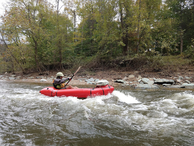
First packrafting trip on the east coast complete. I went with Darren from easternpackrafting.com. He picked me up at BART , sorry, Metro, and we drove out to Point of Rocks on the Potomac, biked up to Taylorstown, locked the bikes up, and floated the Catoctin out into the Potomac back to Point of Rocks. The Catoctin wasn't more than class I or II, so it didn't have the adrenaline or endorphins of trail running, but it was very pretty. The trees were changing colors. The creek was in a winding, sometimes narrow gorge that felt more remote than it was, and we saw a beaver, herons, and multiple deer bounding across the creek. It rained yesterday, which was likely the reason the creek was runable at all, but it was certainly only runable in a packraft, and too shallow for a kayak or canoe. The weather was in the 50's, but the water was shallow and the creek narrow, so I didn't bother with a wet or dry suit, just wore my rain gear, and that was fine. I often go through ...

Grindstone 100 Race Report

Image
I ran the Grindstone 100 this past weekend. I signed up over the summer while I was hiking. I chose it because I want to run at least one 100 every year, it's a Western States qualifier, considered fairly difficult, it's reasonably close to DC, and it's soon after I would move here. All those sound great, right? It's an out and back, and the weird thing about it is its 6PM start, which leads to a goal of avoiding the second night. I essentially didn't train for it. Since June, I ran the Canadian Death Race, and I ran two group runs with Virginia Happy Trails and the Woodley Ultra Society, and that's literally it for runs longer than two miles. So this was a test of how well slow hiking on the GDT and in Alaska translates to running. Not perfectly is the answer. I picked up my rental car Thursday night, but made the mistake of getting it from near the airport, just because I'm used to that and assume it's cheaper. That took forever and I didn't ge...

Washington DC

I am in Washington DC now. I'm staying with my friend in Adams Morgan. I start work on Monday. I'm very happy to be reunited with my dog and my girlfriend. I had to buy a new wardrobe because almost all of my posessions are in storage, and I don't want to pay to pull them out more once, so I'm trying to buy a townhouse ASAP. To distract myself from important work and life things: 1) Does anyone want to buy my size small ULA Epic? It's still in good shape after one  month of use in Alaska. I think the pack is well-designed, but I should have purchased a medium. If you wear a pack that's too small, the load lifter straps aren't effective, and you can't get the weight off your shoulders. 2) My Tarpent Contrail has met its maker after 8 or so years. Or at least the zipper has. (If you set up the shelter on a muddy/sandy glacier, just DO NOT use the zipper. It's too delicate for that kind of dirt!) If I buy something to replace it, what should it be? I...

The creek behind Fred Meyer

And for my last night in Alaska, I'm stealthing behind the Fred Meyer in Soldotna. Hitching out of Homer was a little hard, as the speeds were high and I got dropped off from my first ride at a bad spot with auntie in everyone's eyes and then narrow shoulders. Now after a good ride to Soldotna, I'd rather camp and get an early start, and it's actually not a terrible spot. Actually, I don't really know that, since I got here in the dark. But I'll have a chance of one more night of northern lights this way. 

Kachemak Bay State Park

One of the best days of my life. I'll tell you about it later. 

Homer

I flew from Tustumena Lake to Homer today. I could have (a) continued on my original route, with seriously terrible bushwhacking, (b) found the map at the cabin last night and tried a potentially boring but easy but potentially almost endless bushwhack route down old house trails on the Funny River (c) run into the hunter with a boat I met and asked him for a ride, and he was willing or (d) kept my plans to fly out, since I didn't haveuch cell service to cancel anyway. I went with D. The views were even better than I imagined. Homer is a cool, funky little town with an odd mix of tourists, fishermen, and outdoorsy types, but a bit too spread out. What next? I don't know. I have to be in DC to start work on the 17th.

Emma Lake

Awful bushwhacking to start the day. Amazing tundra all afternoon. Awful bushwhacking to end the day. Staying at the Emma Lake fish and game cabin. And I'm flying out tomorrow. I got reception up high and realized, hey, I can take an air taxi, because that's part of the Alaska experience, fly to Oakland in a couple days, and the government will fly me to DC to start my job next week. I've had my fun, but I don't want to bushwhack anymore right now. 

Jeebus

4 mfing miles as the crow flies. Descent to Benjamin Creek difficult. Found game trail, tried to take it upstream to get above cofluence and avoid the canyon below. (This definitely would have been a good idea on the day I floated the Yanert and had to deal with Dick Creek to get there.) However, the game trail improved, and when I gave up and headed downstream, and eventually hit Benjamin Creek downstream of the canyon, the creek was chill and pretty easy to cross. Then I crossed and went upstream on Killey River, and didn't really know where would be best to ascend to the alpine. All I know is a creek way on the other side that I'm aiming for, but not what drainage or anything to take to get there, and everything is steep and brushy. After a false start, I chose the least steep contour lines I could find, and eventually found a game trail, which I named Hallelujah Game Trail. But it ended at a small knoll, and I'm not really above treeline yet, unfortunately. More bushwha...

60.285779,-150.334727

Good day. The river was foggy and cold when I woke, but I couldn't fall asleep again, so I packed up and paddled off. The canyon was fun to run again, but not quite as exhilarating as the first time. Crossing Skilak lake was mostly drudgery. I picked the shortest line for safety's sake, but when the lake stayed chill, if not glassy in the middle, I adjusted and got to shore right where the Cottonwood Creek trail goes up. My pack is stupid heavy, so the climb wasn't that fun, but above treeline the view of the lake was stupendous. Glad to be hiking again, in  wilderness. Then I contoured around some lakes, sometimes on game trails, sometimes bushwhacking, to try to get to Benjamin Creek, where I might find game trails to help cross the Killey River valley. We'll see. Could be a lot of bushwhacking, and down in the valley it would be awful. My camp is exposed but I have a great view of the valley below. 

Kenai River, again

I got bored with the lower Kenai River. After I put in this morning, there were a few nice spots with more golden eagles and fish and loons and ducks, but we were out of the drift zone, so all the boats were motoring around and pretty soon it was private property and houses on both sides. There was one bit of excitement at Naptowne rapids, which I got out to scout first. Then I chatted with a local fishing guide who discouraged me from hitting the rapids dead on ("5-6 foot wave train, which could flip your little boat") so I just skirted around them and missed most of the fun/danger. The waves were in fact large, but I'm guessing it would have been fine. What are my drysuit and pfd for, after all? If I'd been with a friend we would have run them repeatedly since it's easy to pull out right after and walk a trail back to the top on public land. After that, I just wanted to be done.  Nearly solid private property, and the river was chill enough that I could get out ...

Mouth of Skilak Lake

Woke to the sound of boats and fishermen. Well, that was after I woke several times to shooting pains in my shoulder from trying to use my PFD as a sleeping pad. The fog on the river was beautiful, but too cold for me to get up. So I slept in a little more, packed up, and paddled. The river wasn't tight yet, I apparently hadn't passed Jims Landing yet. Once I did, the fun started. The rapids were really a blast. I was comforted to know that the fishing boats run them, sincd then there were bound to be a bunch of people around in case I got in trouble. No worries, all went great and the rapids were over too quick. Then I had a slow, laborious paddle of Skilak Lake. So slow. I almosy asked the passing fishing boats for a tow, but instead I just hitched from Upper Skilak Campground to Lower Skilak Campground, skipping six miles (and as many hours?) of paddling. Got back in and paddled a quick mile (no headwind! Setting sun and jumping fish and loons) to where the lake becomes a ri...

Kenai River

Lovely day on the Kenai. The lake was slow going this morning, so I pulled out at the power station. There's an access road, and I was thinking I'd just walk it, but then a truck rolled by right as I came to the junction and who wants to carry a heavy pack 10 miles on a hard gravel road when you could be rafting? So I caught the ride to Cooper Landing, bought some snacks, got some info on the river, and put in. The easy part from Cooper to Sportsman's Landing was easy. Camped just below there, tackling the canyon tomorrow. Trail I can walk if I don't feel comfortable running it. Saw several bald eagles and then three huge golden eagles. Huge, I tell ya. Sportsman's Landing is also a sight. So many fly fisherman. The river does stink a little with dead fish, but it's all good. The weather has become fantastic. Clear skies last night, possibly again tonight. Come on Aurora Borealis! 

Kenai Lake

Did I mention there was a fun bluegrass band in town and that Hope is really cute? I camped at the bar campground which is right on the water, Turnagain Arm. In the AM I took my time getting a breakfast burrito, reading more of East of Eden, and addressing some postcards. Some young local hikers I met gave me a ride to the Post office and I picked up my raft and some food. Luckily I'd actually sent myself a decent amount of food, so I didn't have to hitch to a grocery store. Instead I hitched to whichever of Cooper Landing or Primrose, and thus whichever end of Kenai Lake I could get a ride to. Primrose was the winner. I wanted to paddle some of Kenai Lake first since it's flat water, and I figured I could get a day or two in to test out my new drysuit, which I just picked up at REI in Anchorage the other day. Unfortunately the wind was against me all day, but other than that everything worked out great. I probably didn't start paddling until 2:00, but that's OK. It...

Hope, Alaska

Seward to Hope done. Had a nice campsite near Resurrection Pass last night, easy day over the pass and down today. The pass was nice, but mellow. Nothing too exciting, but mostly clear skies. It wasn't all under tree cover, but some. My feet hurt a little, especially on the hard gravel road into town from the trailhead. Hope is small. I stopped at a diner ("Food on Second") for some sandwiches, and the bar has live bluegrass tonight.  I could camp at the bar for $10,  or just stealth somewhere. I need to hit the PO, and then hitch to a real grocery store tomorrow. I had 12+ days of food when I was in Denali, but I planned poorly and sent a bunch of it home instead of here to Hope. Oh well, it's only money and time! Pleasantly surprised to actually get data reception on my phone here. I only just now realized that Google Fi is just the best of Sprint, T-Mobile, and US Cellular, not Verizon or AT&T. So mostly I don't get any data service. John and Daisy have gon...

Juneau Creek

Possibly my biggest mileage day in Alaska so far, given that I was on maintened trail all day.  Passed the second big lake, and hit the halfway point of this section. We're all pretty bored with this section (under the trees, views not great) and John and Daisy decided they were done. Off to the Kings Basin High Route for them. I need to get my raft from the Hope Post Office by Saturday at 1:30, so I kept on. The Resurrection Pass half of the hike immediately started being a bit more interesting. Lakes, and the trail isn't all under tree cover. Still very mellow, but less boring. I got most of the way to the pass. May not make Friday PO hours, but definitely should make Saturday. Then Hope to Homer? Or...? 

Aspen Flats Russian River

Well, the freezing swamp was still there in the morning but it ended pretty quickly. So we were on decent, though brushy trail most of the day. Stopped to cook wild mushrooms and play cards at a public cabin for a bit. Hoped to end up at another cabin for the night but no dice. Did see a griz catching salmon, so that was cool. Mostly the trail wasn't that interesting scenery-wise, unfortunately. Under tree cover too much. 

Resurrection River

Jeebus, Alaska is trying to kill me. We got to Denali, me via the Yanert, and then Revine Creek ATV trail after the Yanert narrowed up and turned into a wave train. It was fun but a little daunting by myself with no drysuit on a cold day, so I took the safe and boring and kinda sloggy way out. Daisy and John soon met me in Healy where we spent the night recooperating. We went into Denali the next day, and started talking to rangers about permits, but we noticed that the 10-day forecast for Kenai, Hope, Homer, and Anchorage all show solid sunshine, while Denali showed more of the same rain. So I watched the touristy sled dog show and we bailed on the Alaska Range traverse. We weren't going to complete the whole route anyway, so why suffer when we can see equally cool stuff nearby? Maybe I'll come back later in life and actually get to see Denali instead of being near it while it's covered in clouds. Hitching to Anchorage was easy. John found a contact to get us out of Anchor...

Healy

We're done. Possibly for good, but we'll see when we get to the ranger station tomorrow. It ended well. Yesterday was gorgeous! I built a fire on a beach of the Yanert and then saw the northern lights. Today was mostly overcast. I paddled some more, but the canyon got a little tight and the waves pretty big, so I got out before the Yanert meets the Nenana. Didn't seem like a smart idea to be doing that without a drysuit. It was an uneventful ATV trail walk out from Revine Creek to the highway. Pizza, beer, cheesecake, trying to fix my shoes with massive amounts of Shoe Goo, laundry, shower, and a hotel room. 

Yanert Fork!

Crossed Big Grizzly, split our group up, and I hiked up little Griz, down Dick Creek, bushwhacked, and got to the Yanert Fork, where I started rafting! Fun! 

Big Grizzly Creek

A hunter guide walked into our camp as we were getting going this morning. I got going, and talked with him and his employee (an 18-year old kid from Michigan) and then met their client, who'd just shot a sheep two days ago but took a spill in the river, hence the guide and employee coming to help him carry out the meet. Anyway, nice guy, the hunter. Then we went up to the pass, down from the pass, crossed the Wood River without too much problem, and then followed it all day, either on the flood plain or in the brush beside it. Mostly the latter. Then we hit a feeder, Big Grizzly Creek, and it is very rapid. Like, crazy, surprisingly so. Damn! Any given creek in Alaska can pin you down/ruin your day/kill the best laid plans. We are camped right next to the spot we'll try and cross tomorrow morning. It's wider than the rest, and the surface is calmer. Still fast. 

West Fork Little Delta

The glacier thing ended fine. Just a bit more and we were very close to the source and were able to cross the flow no problem. It took a long time to bushwhack back down the glacier and up to a bench though. We're all slow with heavy packs. Hiked up to Buchanan Pass and down to the West Fork Little Delta. Saw a complete caribou skull, and picked up a small moose antler that is light enough I can carry home to George. (Giant moose antlers to heavy to pack out are up and down most brushy drainages.) Best of all, it didn't rain today! Well, barely, just a couple sprinkles. Mostly it was cloudy but we actually dried out gear in the half sun for a few minutes in the morning. Nice to be able to sleep in my clothes and not have to do a dreadful change into wet clothes tomorrow morning. 

Benighted on Gillam Glacier

West Hayes was easy. We followed  the creek down, passing dozens of moose antlers, until it got brushy. I went high and B&C stayed low, we met back up at Whistler Creek, which looked bad, but was split into enough pieces that it was doable. Then we went up the East Fork of the Little Delta to the glacier. We got greedy and thought there would be an easy way a road right at the toe. We wasted 30+ minutes walking halfway across on flat stuff below the moraine until we realized there was a rager flowing blocking us from getting on the glacier. So we backtracked, and stayed close to the front edge, but we couldn't find a way--the flow is strong and above ground. At least we found a level place to camp. We'll ascend higher in the morning. This flow has to go underground somewhere. 

Hayes Glacier

Crossed Trident Glacier in good weather this morning. I didn't like the footing (I actually prefer the icier muddier stuff, this was older, sandier, bigger loose rocks) but it was fine. Weather slowly got worse and worse, and we crossed Hayes and circled around in bad weather, getting cold. We're camped in the moat, and hope the ford of west Hayes Creek will be such that we don't have to do much of anything on the glacier. 

Trident Glacier

Wowwowwow! Today started off with a bit of a fiasco, in that it took longer than necessary to get across the Delta River, even after the last person was 98.5% across. My boat almost blew away, our communication was garbage, etc. But it all worked out and we started the real hike and saw huge herds of caribou and the view from above the Trident Glacier was amazing. We're camped right next to it and will cross it in the morning.  Weather wasn't too bad today, just cloudy. Starting to rain now. 

ABC is 2/3 west of the Delta River

Stressful day for Alaska Bumble Club (ABC). I spent Saturday at Black Rapids Lodge rafting across the Delta River and back with three Alaskans who did the same hike we had planned a few weeks ago. The river was big and fast, but the worst parts were easily avoided (at least, I avoided  them and I have limited boating experience, mostly having owned a sea kayak for a few months in the Bay Area. Two of the Alaskans managed to not avoid the big holes and instead hit them dead on. Whatever.) B&C (J&D) returned from Fairbanks with cheap rafts. These rafts have been used by friends on chill crossings of the Colorado River, so we thought they might have a chance against the Delta. We walked to where I thought one of the Alaskans (Steve, the one who owns a packraft and avoided the holes) had told me the easiest crossing of the Delta River was. Turns out it wasn't the right place, but it didn't really matter, the wind in the river valley was freaking nuts. Daisy and I checked ou...

Black Rapids

Hey hey! Leg 1 done, and everybody is alive and reasonably happy! We woke early to more rain and cold, and the ATV track we took all the way from the cabin ~10 miles to the Richardson highway was almost 1/3 underwater, so it wasn't much fun, but we made it. We caught a hitch from Fish Creek right where we came out to Black Rapids Lodge to pick up our food drops. The woman who drove us said August in this area is always crappy, but this is the worst she's seen in the five years she's lived here. However, as soon as we crossed to the north side of the range, the weather got nice, and the forecast calls for two more nice days before 40's and rain returns. We spent the rest of the day acquiring more gear and food, or trying to salvage existing gear, namely one of the DIY rafts. In the end, two headed to Fairbanks to get something to safely get themselves across the Delta River. One stayed near Black Rapids Lodge, and talked to the owner who just completed much the same trip...

Heinz Camp

Very short day. We didn't pack up until 10, since we were all wet, cold, with colds, and it was raining. But we crossed a freezing glacial flow to start the morning, then crossed the Gakona glacier without having to cross much of any ice, and then pretty shortly after we got off it, we hit a decent road/trail that made what would have been awful bushwhacking quite easy. Then we walked through an old camp, and I had the door of the cabin pried open before J and D caught up. Do I know how to use one of these? Do you mean can I light a fire? Uh, yes. And that was all it took. Our gear is strung on lines by a roaring fire. Hot meals. A lantern with gas to spare. It's all good. We're only seven miles from the highway, but we'd be camping next to it in the rain if we'd continued on. I normally would feel dumb for doing only a 10-mile day, but, getting my ass kicked by glacier crossings and 40 degree rain for half the day (5th day in a row) then spending half the day roast...

Back on Track

After the bad spill in the Chistochina we hung with the miners all day. They were very nice to talk to and they happily shared their supplies with us which was greatly appreciated. We slept in the old Post Office--they said 18,000 people used to mine up there. Not anymore! Today we packed up and headed in the Chistochina glacier. We found a large lake at the mouth and took turns paddling my boat across the mouth. The current looked essentially still, but it definitely was not once you were in it. Which basically makes me think all the f*&$cking ragers we have forded that I maybe thought I'd rather paddle would be not so great an idea. Anyway, we crossed the Chistochina glacier mouth lake by boat, then walked over a pass and down to the West Chistochina glacier and crossed that on moraine and flat glacial ice. Slick as heck, but no falling in crevasses. We did some nice ridge walking, and are very close to the Gakona river and it's glacier. Hopefully this is the last glacier...

Alaska, Man

Shit, shit, shit. Shit. The Chistochina River. All it takes is one bad ford. It rained all yesterday, and much of the night. So the water hadn't receeded. We were already freezing after a miserable night, so I said that if I'd been alone I would have just stayed in my tent all day. But together we thought it was worth a shot. In John's eddy I was ok, I think, but Daisy took a bad step, I lost John's eddy, and Daisy and I went down. I went back to the mining camp we'd just crossed for help, because John and Daisy got across, but I swam back. We lost some gear: one boat, one large tarp, and four trekking poles. Maybe if we stay high on glaciers we can make it out to Richardson Monument on foot? There's an airstrip here, that's always an option. Glad to be alive and warm. Arizona trail sounds nice right around now. 

Chistochina

Yesterday went up the Dry Too to Gillette Pass in the rain. So cold. Toes. Thank God for neoprene socks. They made a big difference. Down the pass, on a road! There's a surprising amount of road here, though every creek worth a damn washes them out for a while. Mining and hunting, I guess. Instead of going down (up?) Dry Canyon Creek we went over some pass, but that required crossing the glacier that feeds the Slana which was too big. So we camped. In the morning it wasn't no thang! Glad it didn't rain all night. Cross the glacial flow, then cross several more glacial flows, one glacier itself more for fun than out of necessity--it was mostly rock but some super hard ice, one tiny tiny crevasse, over Chisna Pass on a road, through a mine, and down to the Chistochina River. Too high to cross tonight, and it's been raining all day and we're all cold so we're camping early (still 18 miles for the day) and will cross or float tomorrow. Wonderful views when the cloud...

Day 1, 20 Miles to Dry Tok Creek

Camped where the highway crosses the Tok River last night. Many thanks to Daisy's dad and grandma for an amazing shuttle to the start and help with errands. Started late after doing last minute sealing on the packrafts, then walked an ATV road. Then forded the Tok a bunch. Then found the road again. Avoided fords on game trails. Pack is heavy. Fords are deep. I thought I was having the hardest time with the fords but Daisy got swept and lost gaiters on the last one. Now we're headed up the Dry Tok which is much smaller. Passed a hunter shocked to see us. He gave us some info on what's coming up. Also passed a big compound with a plane and a runway and a Ford Bronco and a Duece and a half, etc on the Dry Tok. Saw two wolf or coyote cubs. This is everything I expected. 

Fairbanks

I made it to Fairbanks. The question is whether, or when, I'll make it out.  Saturday: run Canadian Death Race. Got all worried about my crew being dead in a car accident, when of course they just left a few hours late, etc. and weren't able to find me at aid stations. Race was mediocre other than that. Some awful (boring road, nothing substantive food-wise at aid stations), some great (super steep and muddy sections). Sunday: drive the Icefields Parkway to get Amy a taste of the Canadian Rockies and back to Edmonton. Monday: find out my pack is too small, order replacement. Be dumb, try to renew drivers license online, even though you can't change address online, and I need to change address. Buy $600 (Canadian) worth of gear at MEC. Tuesday: be dumb, break phone. Order replacement phone. Find friend in US to go into my email and click a freaking link, since Internet can tell I'm in Canada (and Berkeley VPN no longer works) and link doesn't work in Canada. Wednesda...

Done

Grand Cache I'm done. Last day was a doozy. The trail became a road as soon as I left the cabin. I woke early after a great night's sleep and made coffee and hot beans. (I heated water is all that means. Not carrying a stove makes that a big deal.) Then the trail was nice. Either an old road, now closed, or just a horsepacker super highway. The ford (stop it phone! Don't autocorrect ford to Ford or fords to Ford's! Especially with an apostrophe! Stop it!) of Sheep Creek was easy. Then up and over to the Muddywater River. I stared at it a long time. I was almost set to go, then I found the place the caribou and moose cross. Then I swam it. First ford I just swam from the get-go. Artistic score very low, but technical score at least not a zero, since I'm alive. Then around a boring low mountain in the trees and down to another crossing that showed a gravel bed on the map. So maybe it was braided? Nope, not really. I studied it for an hour before I found trees in the r...

Glorious Cabin

What a glorious cabin! The route to GC is definitely for horses. Lots of fords. A big burn. And it's raining buckets. I almost stopped several times. The last time I was only a few hundred yards from the unlocked ranger cabin. With food! And a stove and a propane heater! I really should have checked the chimney first, but once I took the giant pot off it, I think I will neither asphyxiate or burn the place down.  Here's hoping for followable trail and doable fords tomorrow. Should have 50km left.

Kakwa

Done. Finished the GDT around 7:30pm today, July 31. Stayed at Kakwa Lake for an hour or so talking to a Swiss couple who had hiked a few sections, ate beans (with hot water!) and chocolate. Turned around. Made about 6.5km back up the muddy trail. 25km back to where I cached my extra food at Sheep Creek, then 55km down to Grand Cache. I really hope the rivers are all fordable on the way down! I asked the FB group for info on that route, but nobody had any. Here's hoping. Did the high route over Wapiti Mountain today. Excellent.

Casket Creek

Today was beautiful, if a tad wet. I am alone out here in a huge wilderness. It is great.

75km to Kakwa

Bailed from the high route after doing most of it, and taking the app guy's recommended route. It sucked below treeline, and the next 8km along the Jackpine River sucked to. The trail should end at Robson. Have I mentioned that? Trail should be better tomorrow. 75km to Kakwa, 30 km back up, 55km to Grand Cache. 160 in 4-5 days? If decent trail exists we're fine. If it's unmaintained unmarked horse trail from 30 years ago, something has to give.

Spider Creek

Jackpine High Route! The route is amazing, the beta is terrible. Woefully inadequate to be part of a recognized alternate on an official trail. The guidebook description is 22 lines for 49km.  Which side of this lake should you go on? What compass bearing should I take? What elevation should I traverse at to avoid the cliffs? You shouldn't just throw up a half-ass GPX route that literally has you walking off a cliff and assume people can figure these things out. Fine, there's a warning that this is the hardest section, but really, if you're going to send people out a route you made up, you need to provide more detail. (Feel free to do a badass route, share no info, and have no one else do it. That's totally an option.)  Venting done. Need to conserve battery. And energy! Maybe halfway through route, much slower than regular trail and I have no time to spare!

119km to Kakwa

Between Bess and Jackpine Pass. Long day. As always? As is my wont? Woke up late, after being cold and not sleeping well. Then my food was heavy. Most I've carried the whole trip. Spent a while at a campsite sorting it and it's seven generous days. Plus two pounds of peanut butter. What sort of amateur hour is this?  But if the trail keeps going like this, I might need it. Jasper's North Boundary Trail was decent, but then I turned up Chown Creek. No trail, which is fine since it's a nice flood plain. But fording it was bad. Cold, and I got swept a little. More like knocked down, and was about to get swept, but I was already most of the way, so just pushed and grabbed and crawled till I was on shore. No harm no foul. It was still warmish out (7:30pm) so I just switched shirts and kept walking. Definitely my worst ford experience of the GDT. The dumb thing is there's a bridge that you cross when you first come to the creek, so this is crossing *back* and you can stay...

Robson

At Robson VC. Back up to the top! It's a 50-56km side trip to resupply today. On to Kakwa and Grand Cache!

Moose to Adolphus

Descended Colonel Creek, then climbed up Moose Creek in the mud all day. Some was a nice flood plain, other parts not so much. The pass itself was stupendous with wildflowers and glaciers, but also mosqies and a mom and cub griz. They were far away, so not threatening, but still probably not wise to hang out too long. Descended from Moose Pass to the Smokey River, one of the tougher fords. I thought I'd have to camp there to cross in the morning but at 10pm it was doable. Split in two, but totally opaque. The second half started pushing me downstream, but it was only a step or two more and I was across. Kept pushing for a legit campsite, but unfortunately it doesn't have much in the way of bear storage. I'm planning to leave my food (I carry the bear proof ursack, but I'm sure hanging it too would make others feel better) for a quick down and back up to Robson tomorrow. Mountain in view. It's huge! Also need to buy socks since a pair and a half fell off my pack yest...

Horse Camp

Rough day today but turned out well. Stayed dry after getting in my tent in a downpour last night. Woke up, and skies we're cloudy. All bushes were wet, and they stayed that way most of the day. So I was thoroughly soaked. The sun slowly came out more and more but it wasn't fun to stop for long since it was a bit cold. There were wild blueberries so that helped.  Loooong ascent up the Miette River, on brushy, overgrown horse trail, totally without views. Then at the top, the views were great, but the pass is a huge meadow/bog and mosquitos we're the worst I have ever experienced. Soooooo many. Could kill ~10 with one slap. Of course I was wearing long pants, long shirt, jacket, gloves, and a headnet, so they can really only penetrate one of my gloves, but sometimes they notice my pants don't totally go to my shoes so they swarm ankles, and all the covering can get hot, and the net makes it harder to see the trail, especially in direct sunlight. Fun to sit and let them s...

The Soothing Highway Sounds

Everything was dry, and now it's not! Wow, that was quite the downpour. Credit to the trusty Henry Shires Tarptent for going up quick and keeping me dry (once I'm inside) with such a thin and flimsy-appearing sil-nylon layer.  Spent the day in the town of Jasper doing errands. New shoes, waterproof pants I should've been carrying all along, new socks, plus less fun stuff like trying to roll over my retirement account so I don't get tax penalties, trying to change an investment account address so I don't get tax penalties, trying to get health insurance so I don't get tax penalties... I really had to stretch those to make it all about taxes; there are other totally non-tax things, but they're all Society, Man! Society! Why can't I just hit pause, make my credit card pay the balance automatically, and mountains for three months without having to do forms every three days? (Oh, yeh, moving your family, stuff, and job across the country takes effort. Forgot....

Jasper

Leaving town of Jasper on long highway stretch to start next section. Mt. Robson Visitor Center in a few days.

Trapper Creek and Farts

Well, around 3pm the weather looked like it was maybe improving a bit, plus my tent was just smelling like farts really bad, so I decided to pack up an move on. The sun came out for a minute, but just before I made it to the ford of the Maligne it went away again for good. The trail got really brushy right before and for a while after the ford, it was pretty awful. But somehow my feet were fine, it was hands that were hating life. Regardless, I made it to Trapper Creek campground for 11km on the day. It is still raining hard. I have 6km to the parking lot for the Skyline Trail. If the weather tomorrow is good, well then all is well I hike the world famous Skyline Trail. If bad, I'm done. I'll try and bum a ride in to Jasper, buy water proof pants and long John's and wait for the weather to improve. No doubt it is snowing on the Skyline Trail right now, no point risking my life *and* missing the scenery. If I can't bum a ride there a several alternates into Jasper or dow...