My Own Private Badwater. With Snow.
I hiked from Death Valley to Owens Valley. You can see more pictures on Picasa. Videos are at the end, and here's the full trip report:
Late Sunday or early Monday I finished grading exams and mailed off my scores to the professor. I printed maps using the .tpo file provided by Brett "Blisterfree" Tucker on his website, but didn't even have time to double-check that I had actually printed two copies and didn't miss anything. Monday at 2PM I had an interview for an RA job that I don't think I'll get, and at 3:30 or so, the car was loaded and I was headed to Lone Pine. After an 8 hour drive I camped in the truck at Portagee Joe campground just outside town. In the morning my friend Nano and I (who I met at ADZPCTKO a couple years ago) left his car at Whitney Portal and drove my truck to Death Valley. After getting a permit (through perhaps the easiest process I've ever had in a National Park) we drove to Badwater, and took off hiking west from 282 feet below seal level at 11:30.
 The weather was a perfect 70 degrees and the polygonal salt slabs were fascinating.
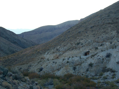
 After crossing the valley we headed up Hanaupah Canyon. I went up this canyon a few years ago in my only previous trip to Death Valley, but I made it a lot further this time. We went until a little after dark (which unfortunately came at a very early 5 PM) when we reached water in the canyon, which happened to be right across from a mine shaft.
 The next day we scrambled to the top of the ridge between the Middle and South Fork of Hanaupah Canyon, then followed it up, and up, and up, and up over steep loose scree fields to the crest of the Panamint range. We hung a left on our only maintained trail of the hike for one mile to reach Telescope Peak at 11,049 feet.
 We doubled back, went north a miler or two on the trail, and then dropped west down, down, down Tuber Canyon. There was a lot of slipping and sliding on loose rock before finally reaching the canyon floor. We followed the canyon down until dark, where we were surrounded by impenetrable brush on one side and a cliff on the other. We could also hear water so we knew we were at the first of a couple potential springs in the canyon, but we weren't going to be able to find it (or get down the cliff) in the dark, so we camped there for the night.
 In the morning, after easily finding the great spring, we exited Tuber canyon into the Panamint Valley, and headed north up it then west across Panamint Dry Lake, and up the road to Panamint Springs Resort.

 After an ice cream break at the resort (from the looks of the place, that word is used loosely) we headed up the road towards Darwin Falls.
 We camped in the wash near the trailhead for the lower part of the falls, then explored them in the morning. There are 9 falls that require fun scrambling to see. We saw the first four. It is humanly possible to hike directly up the canyon by climbing around the falls, but the Hiking Death Valley
 guidebook says there are some low class-5 moves involved, so we took the longer walk around, which Brett lists as the main L2H route anyway.


 After China Garden Springs (above), we scrambled up and up and up another canyon until reaching and then crossing the Darwin Plateau.
 We reached our lone water cache 64 miles in at the intersection of Saline Valley Road and highway 190. This is where Nano and I split up. We enjoyed hiking together, but we clearly weren't going to make it the entire way to Mt. Whitney, and he didn't feel like pushing to get to Lone Pine, so he started hitching back to Badwater to get my car. The plan was for him to switch it out with his car at the portal, but if possible, find somebody to drive my car down to Lone Pine, to where I was planning on hiking. This was at 1:30 PM on Friday. I took off north on Saline Valley road, which went around the Santa Rosa Hills and through Lee Flat Joshua Tree Forest.
 I covered about 15 more miles that afternoon, and went to sleep under the stars under a nice Juniper tree at 7:30PM. At about 12:45 or so, I was awoken by moisture on my face. "I guess I'll set up my tent now, good thing I didn't send it back with Nano," I thought, as the first precipitation of the trip fell. Oh, wait a minute. That's not rain. That's snow. And from what I could tell, it was really coming down. Better to hike in 1-3 inches of snow than 1-3 feet, I thought, so after setting up and then dismantling my tent, I started hiking at 1:15 AM. I soon left the White Mountain Talc Road and climbed up the Inyo Mountains towards Cerro Gordo, an active mining and ghost town. I had camped at about 5000 feet, and there wasn't much snow there, but I didn't reach the summit at 8200 feet until 5AM, at which point there was a good 4 inches of snow.
 All the while I could see squat, but luckily all the walking was on (relatively) easy to follow dirt roads. I would have liked to have hiked north on the crest of the Inyo mountains for a few miles before dropping x-country down Long John Canyon and walking right into Lone Pine, but with the snow and the possibility that the storm block in one of our cars at the Portal, I had to get out ASAP. So I followed the graded Cerro Gordo road down the west side of the Inyos down to the village of Keeler on highway 136. Nano and I got ahold of each other, and it turned out he hadn't switched our cars yet, but it was a relatively simple matter to eat pancakes at a restaurant in Lone Pine and then use my AAA membership to get a giant tow-truck up to the portal in a good 6-7 inches of fresh powder to tow his car down the mountain.
 Simple in that the tow truck was giant but was only 2WD so even it had trouble. Anyway, now that I'm warm and dry (well, sort of, my apartment has serious moisture buildup that is driving me crazy) I'm thinking how the snow wasn't that hard to walk in and jeeps were still going up and down to the Portal for fun, but if I'd been much further out, crossing the Inyos could've been bad, and just because Jeeps can get somewhere doesn't mean you can get a rear-wheel drive sedan there.
All in all I thought this trip was absolutely fantastic. Previously, when a hiker friend of mine told me about his love of the Great Basin, I didn't understand it at all. I just thought it would be hot and boring. But in the fall, Death Valley was fantastic. I do have to say that it was still lifeless, but fascinatingly so. I can literally count the animal life I encountered (insects included) on one hand. How often is that you can do your business, hike all day in the sun, and occasionally sit down in the dirt, and see not a single ant or fly? Yes, seeing a couple desert bighorn would be rad for sure, but if you think about it, the 99.9% lack of life is cool too. With the exception of the snow (which makes for great stories now) the weather was perfect. 60-70 during the day, 30-40 at night. I would prefer a little more daylight, but there's nothing to do about that. And as far as the scenery being boring; I'd disagree completely. I didn't love the desert on the PCT or CDT, but it didn't seem so stark there. By comparison with Death Valley and the Great Basin, the other high deserts I've hiked seem sort of bunched or jumbled together, in Death Valley the contrast between valley and range is stark, leading to beautiful vistas, not to mention truly unique dry lake beds and salt flats.
The route was almost all cross-country or dirt roads, with very little pavement and also very little maintained trail. The roads are often old 4x4 roads that aren't much traveled, and the cross-country sections ranged from very easy (across a dry lake bed) to very difficult (up and down Telescope Peak). I loved the x-country sections, and thought a few of the miles were some of the hardest I have ever done.
As far as logistics of the L2H go, just check out Brett's page. He's got everything you need. I'm happy to answer specific questions. Blake Wood also ran the route a while back (turns out, my escape route was the route he took) and wrote an article for UltraRunning [Thanks, ZG]. Brett's maps are all you need to do the hike, but another great, and very thorough, resource is Hiking Death Valley, which I picked up a few years ago, and is, in my opinion, one of the best two guide books I've ever read (the other being Roper's High Route book).
Videos from the hike:
Immediately after splitting up. I was a little amped at this point, so discount all hyperbole by about 10-15%.
Right before I started out hiking in the snow.
Just after crossing the peak of the Inyos near the mining/ghost town of Cerro Gordo.
A friendly discussion about parking.
Late Sunday or early Monday I finished grading exams and mailed off my scores to the professor. I printed maps using the .tpo file provided by Brett "Blisterfree" Tucker on his website, but didn't even have time to double-check that I had actually printed two copies and didn't miss anything. Monday at 2PM I had an interview for an RA job that I don't think I'll get, and at 3:30 or so, the car was loaded and I was headed to Lone Pine. After an 8 hour drive I camped in the truck at Portagee Joe campground just outside town. In the morning my friend Nano and I (who I met at ADZPCTKO a couple years ago) left his car at Whitney Portal and drove my truck to Death Valley. After getting a permit (through perhaps the easiest process I've ever had in a National Park) we drove to Badwater, and took off hiking west from 282 feet below seal level at 11:30.
 The weather was a perfect 70 degrees and the polygonal salt slabs were fascinating.
 After crossing the valley we headed up Hanaupah Canyon. I went up this canyon a few years ago in my only previous trip to Death Valley, but I made it a lot further this time. We went until a little after dark (which unfortunately came at a very early 5 PM) when we reached water in the canyon, which happened to be right across from a mine shaft.
 The next day we scrambled to the top of the ridge between the Middle and South Fork of Hanaupah Canyon, then followed it up, and up, and up, and up over steep loose scree fields to the crest of the Panamint range. We hung a left on our only maintained trail of the hike for one mile to reach Telescope Peak at 11,049 feet.
 We doubled back, went north a miler or two on the trail, and then dropped west down, down, down Tuber Canyon. There was a lot of slipping and sliding on loose rock before finally reaching the canyon floor. We followed the canyon down until dark, where we were surrounded by impenetrable brush on one side and a cliff on the other. We could also hear water so we knew we were at the first of a couple potential springs in the canyon, but we weren't going to be able to find it (or get down the cliff) in the dark, so we camped there for the night.
 In the morning, after easily finding the great spring, we exited Tuber canyon into the Panamint Valley, and headed north up it then west across Panamint Dry Lake, and up the road to Panamint Springs Resort.
 After an ice cream break at the resort (from the looks of the place, that word is used loosely) we headed up the road towards Darwin Falls.
 We camped in the wash near the trailhead for the lower part of the falls, then explored them in the morning. There are 9 falls that require fun scrambling to see. We saw the first four. It is humanly possible to hike directly up the canyon by climbing around the falls, but the Hiking Death Valley

 After China Garden Springs (above), we scrambled up and up and up another canyon until reaching and then crossing the Darwin Plateau.
 We reached our lone water cache 64 miles in at the intersection of Saline Valley Road and highway 190. This is where Nano and I split up. We enjoyed hiking together, but we clearly weren't going to make it the entire way to Mt. Whitney, and he didn't feel like pushing to get to Lone Pine, so he started hitching back to Badwater to get my car. The plan was for him to switch it out with his car at the portal, but if possible, find somebody to drive my car down to Lone Pine, to where I was planning on hiking. This was at 1:30 PM on Friday. I took off north on Saline Valley road, which went around the Santa Rosa Hills and through Lee Flat Joshua Tree Forest.
 I covered about 15 more miles that afternoon, and went to sleep under the stars under a nice Juniper tree at 7:30PM. At about 12:45 or so, I was awoken by moisture on my face. "I guess I'll set up my tent now, good thing I didn't send it back with Nano," I thought, as the first precipitation of the trip fell. Oh, wait a minute. That's not rain. That's snow. And from what I could tell, it was really coming down. Better to hike in 1-3 inches of snow than 1-3 feet, I thought, so after setting up and then dismantling my tent, I started hiking at 1:15 AM. I soon left the White Mountain Talc Road and climbed up the Inyo Mountains towards Cerro Gordo, an active mining and ghost town. I had camped at about 5000 feet, and there wasn't much snow there, but I didn't reach the summit at 8200 feet until 5AM, at which point there was a good 4 inches of snow.
 All the while I could see squat, but luckily all the walking was on (relatively) easy to follow dirt roads. I would have liked to have hiked north on the crest of the Inyo mountains for a few miles before dropping x-country down Long John Canyon and walking right into Lone Pine, but with the snow and the possibility that the storm block in one of our cars at the Portal, I had to get out ASAP. So I followed the graded Cerro Gordo road down the west side of the Inyos down to the village of Keeler on highway 136. Nano and I got ahold of each other, and it turned out he hadn't switched our cars yet, but it was a relatively simple matter to eat pancakes at a restaurant in Lone Pine and then use my AAA membership to get a giant tow-truck up to the portal in a good 6-7 inches of fresh powder to tow his car down the mountain.
 Simple in that the tow truck was giant but was only 2WD so even it had trouble. Anyway, now that I'm warm and dry (well, sort of, my apartment has serious moisture buildup that is driving me crazy) I'm thinking how the snow wasn't that hard to walk in and jeeps were still going up and down to the Portal for fun, but if I'd been much further out, crossing the Inyos could've been bad, and just because Jeeps can get somewhere doesn't mean you can get a rear-wheel drive sedan there.
All in all I thought this trip was absolutely fantastic. Previously, when a hiker friend of mine told me about his love of the Great Basin, I didn't understand it at all. I just thought it would be hot and boring. But in the fall, Death Valley was fantastic. I do have to say that it was still lifeless, but fascinatingly so. I can literally count the animal life I encountered (insects included) on one hand. How often is that you can do your business, hike all day in the sun, and occasionally sit down in the dirt, and see not a single ant or fly? Yes, seeing a couple desert bighorn would be rad for sure, but if you think about it, the 99.9% lack of life is cool too. With the exception of the snow (which makes for great stories now) the weather was perfect. 60-70 during the day, 30-40 at night. I would prefer a little more daylight, but there's nothing to do about that. And as far as the scenery being boring; I'd disagree completely. I didn't love the desert on the PCT or CDT, but it didn't seem so stark there. By comparison with Death Valley and the Great Basin, the other high deserts I've hiked seem sort of bunched or jumbled together, in Death Valley the contrast between valley and range is stark, leading to beautiful vistas, not to mention truly unique dry lake beds and salt flats.
The route was almost all cross-country or dirt roads, with very little pavement and also very little maintained trail. The roads are often old 4x4 roads that aren't much traveled, and the cross-country sections ranged from very easy (across a dry lake bed) to very difficult (up and down Telescope Peak). I loved the x-country sections, and thought a few of the miles were some of the hardest I have ever done.
As far as logistics of the L2H go, just check out Brett's page. He's got everything you need. I'm happy to answer specific questions. Blake Wood also ran the route a while back (turns out, my escape route was the route he took) and wrote an article for UltraRunning [Thanks, ZG]. Brett's maps are all you need to do the hike, but another great, and very thorough, resource is Hiking Death Valley, which I picked up a few years ago, and is, in my opinion, one of the best two guide books I've ever read (the other being Roper's High Route book).
Videos from the hike:
Immediately after splitting up. I was a little amped at this point, so discount all hyperbole by about 10-15%.
Right before I started out hiking in the snow.
Just after crossing the peak of the Inyos near the mining/ghost town of Cerro Gordo.
A friendly discussion about parking.


Hey dude- sounds like you had an amazing journey. Check out a photo in the same spot where I am shorter than you (and everyone else in America).
ReplyDeleteBravo! Nice job! I think you guys are only the second backpacking party to follow this line, more or less. Travis Anderson aka d=rt and his hiking partner hiked it this past June during a cool spell. Those two actually did something a little different around Darwin Falls by following a well-defined burro trail below the lowest falls that connected with the mapped red line east of China Garden Spring. I think this probably beats the roadwalk so will be updating the site & maps accordingly. Glad you got to explore some of the upper falls! Wonder how tricky that is (with or w/o a pack?) I really need to get back to the L2H one of these days and finally walk the walk! (PS - Come back in June for the flies and ants you missed, at least around the water holes!)
ReplyDeleteBy the way, if memory serves, I believe Blake Wood ran a somewhat different route beyond Darwin Falls. I don't think the L2H is concurrent with his layout again until the Lone Pine area.
ReplyDelete